AI Navigation Failure Triggers Helicopter Rescue for Stranded Teen Hiker
A 16-year-old hiker in British Columbia was rescued by helicopter after following incorrect route directions generated by the Claude AI chatbot.
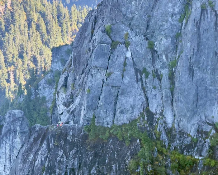
A recent mountain rescue in British Columbia has highlighted the physical dangers of relying on large language models for real-world navigation. A 16-year-old indoor climber, Bryce Vincent Gowryluk, had to be airlifted by emergency services after following hiking directions generated by the AI chatbot Claude. The incident, which took place on the slopes of Crown Mountain, marks what is believed to be the first documented case of a hiker becoming lost and stranded due to artificial intelligence instructions.
From a Day Hike to a Helicopter Rescue
On a Saturday morning, Gowryluk rode a gondola to the top of Grouse Mountain. During his ascent, he used Claude to generate a route to the nearby summit of Crown Mountain and back. Under normal circumstances, the trek is a demanding eight-hour journey that gains more than 2,000 feet of elevation, taking hikers through rugged terrain like Crown Pass and Crater Slabs. Hiking guides regularly warn that the trail is unsuitable for beginners, despite the panoramic views of Greater Vancouver, the Fraser Valley, and the Capilano watershed available at the top.
As Gowryluk followed the AI-generated directions down Crown Pass and through a boulder-strewn valley, the instructions diverted him from the established trail. Instead of a standard hiking path, he was guided directly to the base of the Widowmaker Arete, a sheer 1,700-foot rock wall. The route up this headwall requires specialized climbing gear, including ropes and cams, along with a highly detailed ascent plan. Gowryluk, who lacked the necessary equipment and planning, quickly realized the terrain was too steep to navigate and found himself trapped at the base of the cliff.
After calling his mother and then emergency services, local police contacted North Shore Rescue. Because Gowryluk was stranded too close to the cliff face for a helicopter to land safely, two rescue team members had to be hoisted down to retrieve him. He was subsequently flown to a rescue base located near the Cleveland Dam.
The Limits of AI in Spatial Navigation
While this rescue is the first linked specifically to generative AI, it follows a series of incidents in south-western British Columbia where digital navigation tools have led wilderness users astray. In July, three hikers had to be rescued on the Howe Sound Crest Trail after relying on Google Maps. The application provided highly inaccurate time estimates, suggesting a grueling 14-hour trek could be completed in just over five hours.
Search manager Paul Markey, speaking to North Shore News, emphasized that hikers and mountaineers must not rely blindly on artificial intelligence for mapping wilderness routes. Markey pointed out that these models lack physical spatial awareness and the benefit of real-world experience. "You can’t just blindly follow what AI is proposing to you," Markey warned. "You need to question the information and just see whether it makes sense or not."
What it means for developers
For software engineers and AI developers, this incident serves as a stark reminder of the limitations of large language models (LLMs) when applied to physical-world tasks. While LLMs excel at generating text, coding, and summarizing data, they lack grounded spatial reasoning and real-time geographical validation. When an AI model generates a route, it does not "understand" topography, elevation, or the physical danger of a 1,700-foot cliff face; it merely predicts the most statistically probable sequence of words based on its training data.
To prevent such occurrences, developers building travel, mapping, or outdoor applications must implement strict guardrails. This includes integrating secondary validation layers, such as GPS coordinates and official GIS databases, rather than relying solely on LLM outputs. It is also critical to display prominent warnings to users when an application generates paths in potentially hazardous environments.
Testing how different models handle spatial queries is an essential step in building safer applications. Developers can try top AI models cheaply through one API at https://apixoai.online, which allows them to compare how different engines like Claude, GPT, and Gemini manage complex, safety-critical tasks without committing to multiple platform fees. By carefully benchmarking model outputs against verified datasets, developers can better understand where LLMs fail and design robust fallback systems to ensure user safety.
Source: A teen tried to navigate Canadian mountains with Claude. His trek ended in an emergency rescue — The Guardian AI. Written by the Apixo team from that report.
One key for Claude, GPT, GLM, DeepSeek and more. Pay per token with crypto.
Get your API key